
Boundaries

Squatters’ Rights?
December 6, 2016Keep your old
deeds safe…
Contrary to popular belief, it has never been the Land Registry’s job to say exactly where the boundary of a property is – that is up to the owner, their neighbours and (if necessary) the courts to decide.
If two adjoining landowners are unable to agree the position of their boundary the Land Registry is unlikely to want to try and resolve the issue. It will usually suggest that the issue is resolved by the owners between themselves, or by mediation or by the courts.
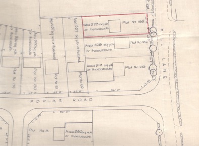
Old deeds, conveyances and transfers may be useful to help work out where the previous owners of the land thought the boundary was. Sometimes the deed plans are accurate, or have measurements or other useful features shown on them. If so the plans can be used to help work out where the legal boundary is. If you do have old deeds to your land it is important that you keep them safe in case there is ever a boundary dispute in the future.
Odd Results?
The Land Registry’s ‘general boundaries’ rule can have results that seem odd – for example, you may even legally own land that is shown on the Land Registry plans as lying OUTSIDE the red line showing the general boundaries of your property, and your neighbour may legally own some of the land lying WITHIN the red line showing your property.
Working out precisely where the legal boundary of your property is can be surprisingly difficult. Often the red line on the Land Registry plan can be misleading – in some cases it may seem to be in the wrong place. This is because in 1925 the Land Registry adopted the ‘general boundaries’ rule for their plans, so that the plans are NOT intended to show exactly where a boundary is – just the ‘general position’ of the boundaries. The Land Registry use Ordnance Survey plans for their title plans/ However, the Ordnance Survey lines on a plan often show a group of features (such as a hedge, wall, fence stream and kerb) as just one line that doesn’t necessarily represent any one of these features. The line may even have been plotted in the wrong place. Requiring precisely accurate plans for Land Registration purposes would be expensive and impractical – which is why the ‘general boundaries’ rule was adopted. This enables a quick and relatively inexpensive land registration system, but at the expense of absolute accuracy.
When Land Registration was introduced in 1925 it was always intended that the interpretation of the correct position of the boundary would take into account the physical features on the ground at the time of the sale of the land, the intentions of the parties to the sale and also any information in any pre-registration title deeds.
In any case, the accuracy of the position on the ground of a line drawn on the usual Land Registry title plan is only plus or minus 1 metre. Often the width of the land in dispute is less than this. You should therefore not try to scale, or measure, from these line when trying to work out precisely where your legal boundary is.
Key pointers to finding the correct position of the legal boundary
The history of the land and the physical position of walls and fences on the land is very important. It is very likely we would have to investigate the history of the boundary and visit the site before we were able to give advice on the position of the legal boundary, since photos and drawings may not present the full picture. However, please let us have any photographs of the boundary as it is now, or how it was in the past as this will help us understand how the boundary features relate to the positions shown on the title documents.
We may be able to offer an opinion on the legal position of the boundary but of course your next door neighbour might have conflicting views. Similarly a surveyor may be asked to offer an opinion, but the true position of the boundary might only be clear by combining both legal and surveying inputs. It may be necessary to accept a compromise.
Court action should be only used as a last resort
Going to court to resolve a boundary dispute is generally a bad idea as it is often costly and the result can be unpredictable. It is much better to try and agree something with your adjoining owner or to try having a formal mediation. The Land Registry cannot help you on this – it is up to you to deal with, using legal and surveying advice or ultimately the court system.
Why aren’t Land Registry plans precise and accurate?
Land registries in many other European countries insist on the use of extremely accurate plans since they adopted the Napoleonic cadastral system.
However, the catch is that in some cases their land registration fees may easily be over £10,000, and their systems can delay the conveyancing process by months.
The English system is therefore quicker, cheaper and more convenient – but at the expense of accuracy.
In 2002, the Land Registry requirements for plans were tightened up and more accurate plans must now be used for all new applications – but the legacy of problems caused by old inaccurate plans and imprecise boundaries will be with us for many years to come.
We cannot prepare accurate boundary plans for you. A reputable RICS land surveyor can prepare accurate plans if these are needed.
You need to check the position of the boundary as shown on any title or contract plans very carefully against what you see on the ground when you visit the property. You must also tell us if there is anything unusual about the boundaries of the land or the boundary features.

